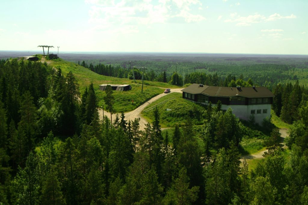
The trail runs along the slopes of Simpsiönvuori, a quartzite rock hill, whose natural features and species differ from those in the area’s other forests. The first and final stretches of the trail wind through a herb-rich forest reserve. The information boards tell you many fascinating stories, such as how many spiders can be found spinning their webs within a hectare; what methods are used for observing air quality in forests; what helped to keep milk fresher for longer in the old days, and what frightening circumstance was still a reality in Simpsiö even in the 18th century. There are several rest spots along the trail.
Getting to the trail
Startpoint 1
Simpsiö Ski Centre, lower parking area
Karhunmäentie 230 -> Simpsiönrinteentie 28, 62100 Lapua
The ‘Luonto-Simpsiö’ signs will show the way from Simpsiönrinteentie to the starting point N62 57.324 E22 56.344, which is located at the furthest corner of the ski centre’s parking area.
Startpoint 2
Ski lodge parking area
Urheilumajantie 28, 62100 Lapua
The ski lodge’s parking area is located at the end of Urheilumajantie.
The ‘Luonto-Simpsiö’ sign will show the way from the parking area to an alternative starting point N62 57.775 E22 58.473, which is located at the end of the driveway leading to the ski lodge, behind the lean-to shelter and rest spot.
Trail description
The Kalliomaanpolku Trail starts from the Simpsiö Ski Centre’s lower parking area and ends up on the other side of Simpsiönvuori Hill, to the ski lodge. Just before reaching the ski lodge the trail passes by a residential area. The trail stays on the slopes of Simpsiönvuori, whose natural features and species differ from those you commonly find in a forest. Simpsiö’s vegetation is extremely diverse, from dry and mesic herb-rich forests on the slopes and in the shade of rocks to moist herb-rich forests along brook banks and even mires. The trail winds through a spruce-dominated forest and across rugged rock surfaces, and passes Rytilampi, a pond known as a nesting and resting place for birds. The rest spot on the shoreline rock provides visitors with a beautiful view of the pond. Along the trail, you will find several information boards that describe the area’s natural features and history, and you should not move on without stopping to read them. To get to the other side of Simpsiönvuori, you hike from the ski lodge along the Piispanpolku Trail, but there are no houses in that stretch. The trail finally ends up back where it started.
Level of difficulty
The trail runs in varied terrain along forest paths, large rock surfaces, exercise tracks, forest roads and duckboards. The Simpsiö slopes are quite gentle both going up and coming down. Some rocky and root-filled sections slow you down in places. There is some variation in altitude along the trail, and also some steep (>35% gradient) and other difficult sections. These sections can be safely negotiated, however, by walking slowly. Clear signposts and markings make it easy to follow the trail.
Good to know
The trail is rocky and uneven in places, so you should wear sturdy hiking boots. In wet weather, the duckboards are very slippery, and you should watch your step on the rock surfaces too. On a warm day you should at least have a water bottle with you, but it is good to take also a packed lunch, as well as some toilet paper with you. There is no organised waste management along the trail, so take a plastic bag with you. This way, you will be able to take away everything that you bring with you. The trail is part of the Luonto-Simpsiö trail network. If you wish to take a slightly shorter circular trail, you can switch from the Kalliomaanpolku Trail to the Piispanpolku Trail at the Rytilampi lean-to shelter, which shortens the total length to 5 km. There is also a connection to the Tohninpolku Trail (6.3 km) that leads from Simpsiö to Wanha Karhunmäki, a guesthouse and leisure centre.
Trail facilities
Information board and a bench at the trail’s starting point, several information boards with stories, benches for resting, three lean-to shelters, firewood shed, swimming spot by the pond and a dry toilet along the trail.
Download and print the route description and map here!